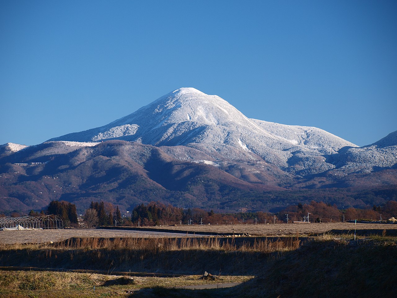
The Suwa Fuji of the northern Yatsugatake
Mt. Tateshina (2,531 m / 8,304 ft) stands at the northern terminus of the Yatsugatake volcanic range in Nagano Prefecture. From the Suwa basin below, its almost perfectly symmetrical cone looks startlingly like Mt. Fuji — earning it the local name Suwa Fuji. It is the highest peak of the northern Yatsugatake (Kita-Yatsugatake) sub-range, and Fukada Kyūya's canonical list of Japan's 100 Famous Mountains gives Tateshina its own entry distinct from the rest of the Yatsugatake range. The summit sits inside Yatsugatake-Chūshin Kōgen Quasi-National Park.
Geologically, Tateshina is a complex volcano whose last eruption is dated to roughly 300,000 years ago. Slow, viscous lava during its final phase produced a unique summit landform: a roughly 200-meter-wide lava-block plateau of angular boulders, too unstable for trees, that gives the summit a 360° unobstructed view. No other peak in the Yatsugatake range has this kind of summit, and it is the single feature most climbers come away remembering.
Three trails, three approaches
Three trails reach the summit, each with a different character. The classic Megami-jaya (Suzuran-tōge) route from the south starts at 1,720 m on the Venus Line scenic highway and climbs 800 m in roughly 2.5 hours. It begins as a gentle larch and birch forest, transitions into a steep rocky middle section, and ends with the lava-block traverse just below the summit. This is the most-walked of the three.
The Ōkawara Pass route from the northeast is the shortest by elevation — the trailhead sits at 2,093 m, so you only gain about 440 m to reach the summit (roughly 2 hours up). It crosses the gentle Futago-yama / Shōgun-daira plateau and saves the steep work for the final 200 m of lava boulders. For experienced hikers chasing the 100 Famous Mountains list, this is the fastest way to bag the peak — and the contrast between mellow ridgeline and abrupt boulder field makes it the route that best dramatizes Tateshina's volcanic geology.
The Tateshina Ranch (Nanagōme) route from the northwest reaches the 7th-station trailhead (1,900 m) by gondola or road, then climbs through forest to Shōgun-daira and onto the summit in about 2 hours. It has the shortest technical section of the three and is what local guides recommend for first-time Tateshina climbers.
Getting there from Tokyo
By car from Tokyo, the Chūō Expressway reaches Suwa Interchange in about 2.5 hours; from there, the Venus Line winds up to the Megami-jaya trailhead in another 40 minutes. By train, take the JR Chūō Line to Chino Station, then a seasonal Alpico Kōtsū bus to Megami-ko or Tateshina-bokujō — service is roughly hourly in summer and on autumn weekends, much sparser in shoulder season. For the Ōkawara Pass trailhead, the access point is Sakudaira Station on the Hokuriku Shinkansen, then about an hour by rental car or shared taxi. Each trailhead has a free parking lot (50 cars at Megami-jaya, 40 at Ōkawara, 100+ at Tateshina-bokujō), but on summer and autumn weekends these fill by 6 a.m. — start early or stay overnight.
The summit and what you actually see
Regardless of route, the final 200–300 m is a scramble up loose lava boulders, marked by paint blazes. Then the trail abruptly tops out onto the flat boulder plateau. At the eastern edge sits Tateshina Sanchō Hütte (Tateshina Summit Hut), one of the highest mountain lodges in Japan at 2,520 m, where you can buy a hot meal, coffee, and souvenirs — a rare luxury on a 100 Famous Mountains summit. The summit marker and the stone shrine of Tateshina-jinja Okumiya are a 5-minute boulder-hop away across the plateau.
The view is the payoff. Because Tateshina stands apart at the northern tip of its range, nothing blocks the 360° panorama. To the south, the rest of the Yatsugatake range stretches away to Akadake. To the west, the entire Japan Alps wall — from the spires of Yarigatake and Hotaka to the broad ridgeline of the Hakuba range. North reveals Mt. Asama and the Shiga highlands; east, the Okuchichibu ridge of Mt. Kinpu and Mt. Kobushi; and on clear days, the cone of Mt. Fuji to the southeast. Few summits in central Japan show this many separate mountain ranges in a single 360° turn.
The striped forests below
On the southwest slope, you'll notice horizontal bands of white-grey standing deadwood — this is shima-gare ('stripe wilting'), a regenerative dieback pattern unique to subalpine fir forests in the 2,200–2,500 m belt of northern Yatsugatake. Mature Abies veitchii and Abies mariesii trees die back in horizontal bands while younger trees grow up behind them, producing a striped appearance from a distance. This is one of the most-studied subalpine ecological phenomena in Japan and is best seen from the middle of the Megami-jaya trail. Halfway up the Shōgun-daira section, Tateshina Sansō hut at 2,350 m sits where the Ōkawara and Tateshina-bokujō routes merge — a useful stopover and the last shelter below the summit boulder field.
What to bring
Treat Tateshina as a real 2,500 m peak. Even in midsummer the summit holds around 10–15 °C and a sustained breeze, dropping below 5 °C in unsettled weather. Bring a long-sleeve base layer (merino or synthetic), light fleece, breathable rain jacket, beanie, and light gloves. Footwear matters more than usual on this mountain — the summit boulder field is much easier in stiff-soled mid-cut hiking boots than in trail runners. Carry at least 1.5 L of water; there is no reliable water source above the trailheads. Standard climbing season runs late May to mid-October. June brings azalea blossoms; mid-September to mid-October the larches turn gold along the Venus Line and the trail is at its most photogenic. November through April the mountain becomes a serious winter climb — the summit dome is exposed and icy, and crampons and an ice axe are required.
In Suwa folklore, Tateshina is the 'little sister' of the Yatsugatake range. When the original mountain god split her family into eight peaks, the youngest sister wept so much that her tears formed a river and filled Lake Suwa below. The shrine on the summit, Tateshina-jinja Okumiya, has been a destination for safety prayers from local climbing parties since long before the modern hiking era.
After the summit
Tateshina is a natural starting point for traversing the northern Yatsugatake. From Ōkawara Pass, the ridge runs south through Futago-yama, Kita-Yokodake, Shimagare-yama, Chausu-yama and onward to Mugikusa Pass — a multi-day traverse that delivers the entire Kita-Yatsugatake range. For a day-trip extension, the Venus Line drive to Kurumayama-kōgen pairs naturally with a soak at Tateshina Onsen or one of the Shirakaba-ko-area day baths. And once you've stood on the lava-block summit looking south, the rugged peaks of southern Yatsugatake — Akadake, Yokodake, Iōdake — start to look less like an abstract list and more like a logical next trip.


