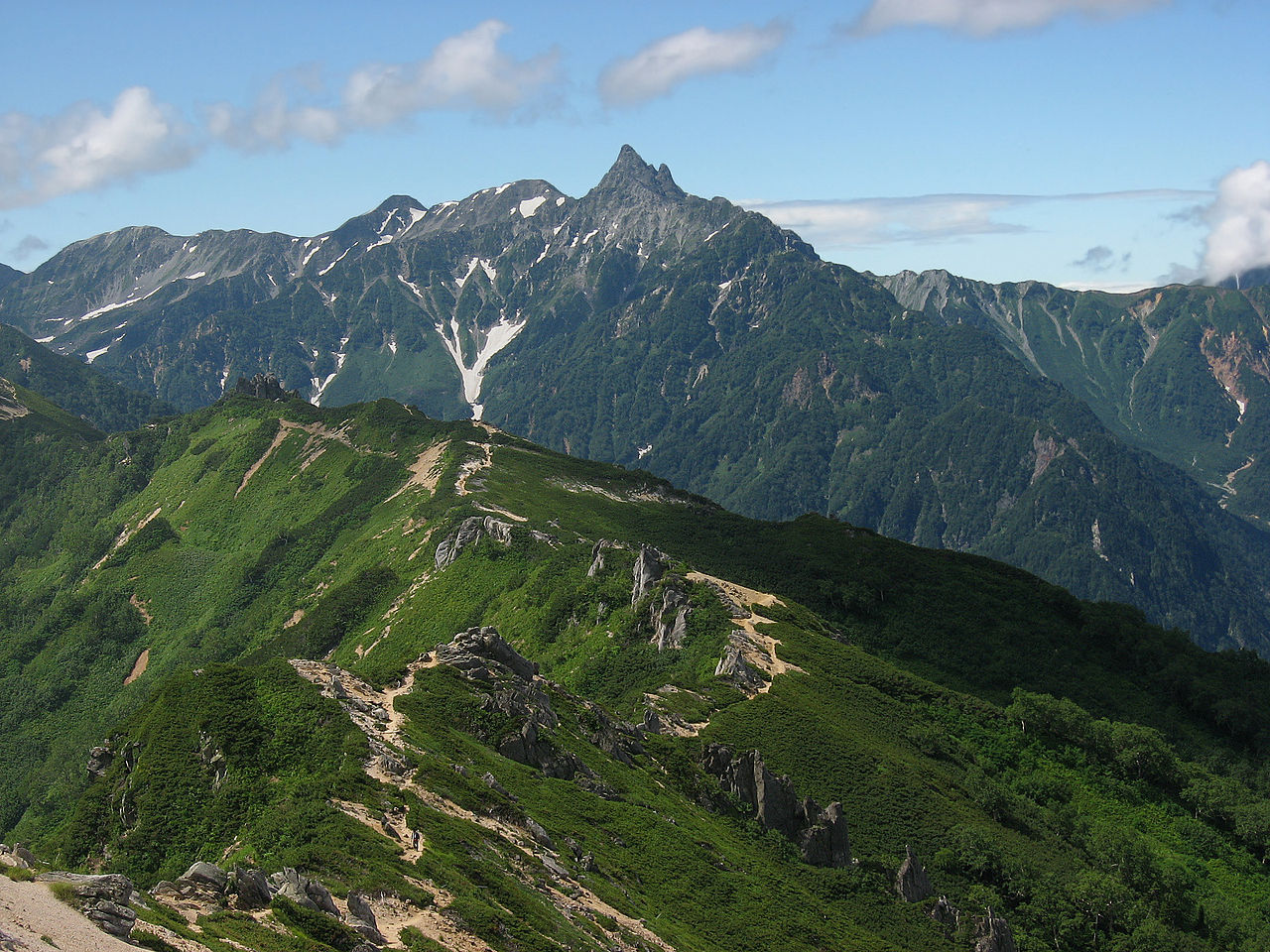
The spear at the center of the Northern Alps
Mt. Yari rises 3,180 m (10,433 ft) on the border of Nagano and Gifu prefectures, at the geographic center of the Chubu Sangaku National Park. Among the long ridges of the Northern Japan Alps, only Yari's summit ends in a near-vertical rock spear — visible and instantly identifiable from any neighbouring ridge. The writer Kyūya Fukada, in his 1964 classic Nihon Hyakumeizan (One Hundred Mountains of Japan), called it the country's Matterhorn, and the comparison stuck. The first recorded ascent was in 1828 by the Buddhist priest Banryū, and the mountain has been a fixture of Japanese alpinism ever since.
Four ways up: Yarisawa, Omote-Ginza, Hidasawa, Kita-Kama
There are four classic approaches. The Yarisawa Route is the oldest and most direct from the Nagano side: from Kamikōchi up the Azusa River through Yokoo, Yarisawa Lodge, Baba-daira, and the long open valley to Yarigatake Sanso (the summit hut). The Omote-Ginza Traverse — Nakabusa Onsen, Mt. Tsubakuro, Mt. Daitenjo, the Higashi-Kama ridge, and finally Yari — is the prestige line, usually done in three days; it offers the most sustained ridge walking in Japan. The Hidasawa Route climbs from Shin-Hotaka Onsen on the Gifu side, the shortest line to the summit hut. And the Kita-Kama (North Spur) Ridge is a non-marked variation route: rappels, route-finding, and exposed rock — a Japanese alpine classic still done seriously, not casually.
Choosing among Yari's routes is less a question of difficulty than of style: a two-night out-and-back from Kamikōchi, a three- or four-day traverse on the Omote-Ginza ridge, or a fast push from Shin-Hotaka. Most first-time climbers take the Yarisawa Route, sleeping at Yarisawa Lodge before the summit day.
The last hundred meters: ladders, chains, and the summit pitch
From Yarigatake Sanso (3,080 m), the final summit cone is roughly 100 m of elevation gain on near-vertical rock equipped with steel ladders and fixed chains. The route is split into separated up-and-down lines where the geometry allows it. In good conditions the round trip from the hut takes about an hour, but during the August peak the bottleneck on the summit pitch is severe — the time you spend waiting at the base of the ladders is often longer than the climb itself.
The view from the summit is a 360° panorama of the Northern Alps: Tateyama and Tsurugi to the north, the Jōnen range and Yatsugadake to the east, the Hotaka peaks across the Daikiretto notch to the south, Kasagatake to the west, and the U-shaped Yarisawa valley directly below. Three-point contact on the chains, ascending climbers having right of way, and leaving your pack at the designated stash point below the cone are the basic etiquette. Helmets are strongly recommended along the entire summit ridge — falling rock from above is the most common cause of injury here.
A two-and-a-half-month window, end of June through early October
The snow-free season on Yari runs roughly from mid-July through early October. In June, residual snowfields in Yarisawa demand snow-travel skills above the Ōmagari turn. The peak in August coincides with Obon holiday traffic; the high huts are reservation-only, and Yarigatake Sanso has almost no walk-in capacity during peak weeks. Late September through early October brings autumn colors to Yarisawa and the highest fair-weather percentage of the year. After mid-October the huts begin to close and the ridge transitions to a winter-grade objective.
Gear for Yari assumes sustained time above 3,000 m. Even in midsummer, ridge mornings can drop below 10°C (50°F), and a fleece plus a wind- and waterproof hardshell are non-negotiable. A helmet is standard on the summit cone; the Kita-Kama variation additionally requires a harness, a sling, and the experience to use them. Boots should at minimum be mid-cut, and a pack sized for two- to three-day food and warm layers. If altitude affects you, an extra night at Kamikōchi or Yokoo before the summit day is a worthwhile investment.
Huts as planning skeleton: Yarigatake Sanso, Hütte Ohyari, Yarisawa Lodge
Yari's huts are not optional — they are the planning skeleton. Yarigatake Sanso, just below the summit, is one of the largest huts in the Northern Alps and the base for the summit pitch. Hütte Ohyari, on the Higashi-Kama ridge, is the classic last night of the Omote-Ginza traverse, with the spear of Yari framed in evening light. Yarisawa Lodge is the indispensable mid-point for any climber starting from Kamikōchi who can't reach the summit hut in a single day. On the Gifu side, Yaridaira-goya plays the equivalent role.
All these huts run on full advance reservation, with peak weeks filling months ahead. Japanese mountain huts are functional sleeping platforms with hot meals, not hotels: shared bunks, fixed lights-out times, and meal-shift rotations. Aligning your hiking rhythm to the meal slots (typically 5 p.m. dinner, 5 a.m. breakfast or a bentō handed out for early starts) makes a multi-day push much smoother.
Many climbers chase sunrise from the summit by leaving the hut in the dark with headlamps. It is a stunning experience in good weather, but the ladders are colder, the rock can be greasy with overnight dew, and any wind makes a real difference. If this is your first time on Yari, save the summit pitch for a clear mid-morning rather than an ambitious pre-dawn.
Reaching the trailheads: Kamikōchi and Shin-Hotaka
Access on the Nagano side starts at Matsumoto, reached by limited express from Shinjuku in about 2.5 hours. From Matsumoto, the Alpico Kōtsū railway runs to Shin-Shimashima, where buses continue to the Kamikōchi terminal (around an hour). From Gifu, the Hida-side approach uses Takayama or Hirayu Onsen, with buses to Shin-Hotaka Onsen. Kamikōchi is closed to private cars year-round; if you drive, you park at Sawando or Hirayu Akandana and transfer to a shuttle bus or taxi.
Getting to either trailhead from Tokyo eats most of a day, so most climbers arrive the evening before and start at dawn. A satisfying alternative is to traverse: enter at Nakabusa Onsen on the Omote-Ginza, walk the ridge for three days, summit Yari, and descend Yarisawa to Kamikōchi. To climb Yari, in other words, is partly to design how you want to cross the Northern Alps.


