1,977 m, and the world's highest recorded alpine fatality count
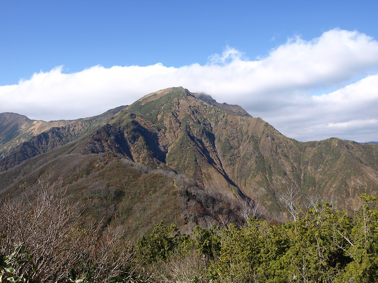
Mt. Tanigawa rises 1,977 m (6,486 ft) on the border between Minakami in Gunma and Yuzawa in Niigata. The peak sits inside Jōshin'etsu-Kōgen National Park, and its summit is split into two 'ears' — Oki-no-Mimi (1,977 m) and Toma-no-Mimi (1,963 m). By altitude alone Tanigawa is far below the 3,000 m peaks of the Japanese Alps, but Kyūya Fukada included it in Nihon Hyakumeizan for exactly the reasons that make it dangerous: steep rock walls, complex terrain, and notoriously unstable weather.
What gives Tanigawa its global reputation is its accident record. From the early Taishō era records onward, more than 800 climbers have died on the Tanigawa massif — the highest documented fatality count of any single mountain in the world (a figure entered into the Guinness Book of Records). The vast majority were rock-climbing falls or rockfall events on the great east face centered on Ichinokura-sawa, accumulated across the post-war climbing boom from the 1930s through the 1980s and compounded by Tanigawa's signature sudden weather changes. The folk names 'Mountain of Demons' and 'Man-Eating Mountain' are not hyperbole — they are part of how Tanigawa is described.
The Tenjin Ridge: the cable-car-assisted standard route
For a regular hiker today, the Tanigawa climb means the Tenjin Ridge route. The Tanigawadake Ropeway lifts you from Doai-guchi Station to Tenjin-daira Station (1,319 m), and the trail traverses Tenjin Pass, Kumaana-zawa shelter, Tengu-no-Tamariba, and Kata-no-Koya hut to the twin summits. About 650 m of vertical gain, 5–6 hours round-trip. Ropeway-assisted, it is genuinely day-trippable, and it is the most popular Tanigawa route.
The Tenjin Ridge is well-built with limited exposure. But Tanigawa's summit ridge is famous for sudden weather change — clear ridge to whiteout-and-gale in thirty minutes is normal. Stepping off the ropeway at Tenjin-daira in 'tourist mindset' and onto the ridge is exactly how underestimated gear becomes an accident when the weather turns. Even at 1,977 m, the gear standard for Tanigawa should match what you'd take to a 2,500 m peak in central Honshu — not what its altitude suggests.
The Nishi-Kuro Ridge: a classic counted among Japan's steepest climbs
The second main route is the Nishi-Kuro Ridge (West-Black Ridge), which starts directly from the trail-guidance center near Doai station and climbs the spine via Rakuda-no-Se, talus, and old glacial scour to Kata-no-Koya and Toma-no-Mimi. It is one of Japan's three classic steep ridge climbs, gaining about 1,200 m of vertical in a single day. This is the historical way up Tanigawa, without the cable car — the line chosen by climbers who want to feel the mountain's full climbing history under their feet.
The standard plan is up the Nishi-Kuro Ridge, down the Tenjin Ridge with the ropeway descent. It can be done in a day, but the Nishi-Kuro climb is sustained forest steep followed by exposed rock ridge, and untrained climbers routinely exceed the published book times. A helmet is recommended on the chain sections; in rain the rock becomes slippery and accidents rise. If you take Nishi-Kuro, plan to depart at dawn in fair weather and reach Kata-no-Koya before the afternoon weather turns.
Ichinokura-sawa: the wall that built Japanese alpinism
The east face of Tanigawa, focused on Ichinokura-sawa, is a place no account of Japanese rock climbing can skip. Roughly 1,000 m of vertical relief across 2 km of granite walls — the Central Buttress, the South Buttress, the Eboshi-sawa Upper Wall, the Cup-shaped Wall, and dozens of other classic routes that shaped post-war Japanese alpinism. Since the 1932 first ascent of the South Buttress by Toshio Fujishima and Iwao Naruse, countless attempts and countless accidents have accumulated here.
Regular hikers do not climb Ichinokura-sawa, but the Machiga-sawa / Ichinokura-sawa walking road from Doai-guchi Station leads directly under the wall. Machiga-sawa to Ichinokura-sawa is about an hour on foot on a paved, vehicle-restricted access road walkable in trainers. Standing at the base of the great wall is the experience that turns Tanigawa from 'a mountain' into 'the geographic monument of post-war Japanese alpinism' — the whole climbing history is built into the rock above your head.
Toma-no-Mimi, Oki-no-Mimi: the twin-eared summit
Tanigawa's summit is two peaks. From Kata-no-Koya hut, the ridge runs northeast first to Toma-no-Mimi (1,963 m), and another 15 minutes along the ridge reaches Oki-no-Mimi (1,977 m), the higher summit. The 'ear' names come from the twin-peak profile resembling an animal's ears from below. The standard Tanigawa climb tags both summits — each is about an hour return from Kata-no-Koya.
North of Oki-no-Mimi the ridge continues to Ichinokura-dake and Mogura-dake. Traversing from Tanigawa to Mogura-dake and descending the Mogura-shindō route down to Tsuchitaru on the Niigata side is a popular long ridge crossing, done in a single day or with one overnight. Beyond that, the Bateigata Ringu (Horseshoe Traverse) — Tanigawa, Buno-dake, Yomogi-tōge, Nanatsu-goyayama, Asahi-dake, Kasagatake, Shiragamon, back to Tanigawa — is a roughly 25 km long-trail loop favoured by experienced climbers.
Tanigawa weather: a mountain that turns fast
Tanigawa's accident statistics owe a lot to its weather. The mountain sits directly on the air-stream pathway from the Sea of Japan to the Pacific, and a clear ridge can become whiteout and gale within thirty minutes. Even in midsummer, ridge temperatures can drop below 10 °C, and rain combined with wind raises hypothermia risk fast. The number 1,977 m is misleading — climbers should bring the same gear and judgment they would carry to a 2,500 m central Honshu peak.
The Tanigawa snow-free season runs roughly late May through early November. June and early July fall inside the rainy season and bring unstable conditions; August is the climbing peak; late September and early October bring autumn colour and a higher fair-weather percentage. From November the mountain becomes a winter objective with avalanche, blizzard, and passing low-pressure system risk on a regular basis — strictly expert ground in winter. For ordinary climbers, mid-October should be considered the season cut-off.
Even on the Tenjin Ridge, gear should match a 2,500 m central Honshu peak. Fleece, waterproof and windproof rain shell, and a light down layer carried in reserve. Mid-cut or higher hiking boots; a 20 L pack for a day-trip; a helmet for the Nishi-Kuro Ridge. Stay off the ridge in the afternoon when thunderstorm risk peaks. The clearer your weather call, the cleaner your trip — and Tanigawa makes that relationship more explicit than any other Japanese mountain.
Kata-no-Koya: the single hut on the mountain
Huts on Tanigawa are sparse. Kata-no-Koya, just below the summit ridge, is the sole staffed mountain hut and serves both Toma-no-Mimi and Oki-no-Mimi. Capacity is about 60 and peak-season reservations are essential. The Mogura emergency shelter on the north traverse is unstaffed but available for emergency use; Kumaana-zawa emergency shelter midway up the Tenjin Ridge serves as a bailout point in bad weather.
Tanigawa is fundamentally a day-trip mountain and hut overnighting is less mandatory than in the Northern Alps or Yatsugatake. Even so, a night at Kata-no-Koya to catch sunrise from the twin summits remains a quietly loved Tanigawa plan. After descent — back at Tsuchitaru on a north traverse, or at Doai on a normal return — Minakami Onsen and Echigo-Yuzawa Onsen are the customary rinse-off stops.
Morning from outside Kata-no-Koya catches Mt. Hotaka and the Oze area to the east, Mt. Akagi and the Jōshū hills to the south, Naeba and the upper Echigo border peaks to the west, and Makihata and the Echigo-Sanzan to the north — most of the central Honshu mid-altitude ranges in a single view. New-moon midsummer nights still give a clean Milky Way over the ridge despite the lower altitude. Watching the dawn light first touch the Ichinokura-sawa walls is an experience only climbers who slept on the ridge ever see.
Doai Station: 70 m underground, then up the ropeway
Access to Tanigawa runs through Doai Station on the JR Jōetsu line, about 20 minutes on foot to the Tanigawadake Ropeway lower station. Doai is famous as Japan's deepest railway station, with the downbound platform 70 m below the surface, reached by 486 steps. If driving, the ropeway parking accepts private cars. The ropeway lifts to Tenjin-daira, and from there the Tenjin Ridge climbs to the summit. The Ichinokura-sawa walking road runs roughly 3 km / one hour on foot from the ropeway lower station to the wall.
From Tokyo the Jōetsu Shinkansen reaches Jōmō-Kōgen Station in about 70 minutes, with a 45-minute bus to the ropeway. Alternatively, the Jōetsu line from Takasaki reaches Minakami and Doai in about 90 minutes. By car the Kan-etsu Expressway from Minakami IC takes about 20 minutes. Tanigawa is the closest serious mountain to Tokyo at this altitude, and the viability of a real day-trip is one of the main reasons for its popularity. After descent, Minakami Onsen, Yubiso Onsen, and Takaragawa Onsen are the local hot-spring choices. Climbing Tanigawa is an unusual experience: a single trip that carries both the weight of 'the world's highest alpine fatality count' and the convenience of 'the closest serious mountain to Tokyo' — a combination no other Japanese peak quite matches.

