The Roof of Hokkaido
Mt. Asahi — known almost universally in Japan as Asahidake — is the highest peak in Hokkaido, at 2,291 m (7,516 ft). It sits at the centre of Daisetsuzan National Park, which at over 2,300 km² is the largest national park in Japan, larger than the entire prefecture of Tokyo. The Indigenous Ainu name for the area is Kamui Mintara, 'the playground of the gods' — a phrase that captures the unusual emptiness of the high plateau: a true alpine wilderness, with no villages, no farms and no roads above the trailhead.
How a ropeway makes this peak accessible
Unlike most Hokkaido Hyakumeizan, you can be on the alpine slopes of Asahidake before 9 a.m. with no overnight camping required. From the resort village of Asahidake Onsen at 1,100 m, the Asahidake Ropeway climbs in ten minutes to Sugatami Station at 1,600 m. From the station, a 1.7-km loop walk takes general visitors past Sugatami Pond and the steaming fumaroles of Jigokudani ('Hell Valley'). The mountain trail diverges from this loop and climbs another roughly 700 m to the summit — about two and a half hours up and an hour and a half down. Total time on the mountain is about half a day, including the ropeway.
Why so many climbers extend the trip
Asahidake on its own is a satisfying day, but it is also the western gateway to a multi-day traverse that runs across the entire Daisetsuzan high plateau. Crossing over the summit and continuing east leads to Hakuun-dake, Chūbetsu-dake and Mt. Tomuraushi — a two-to-four-day traverse that is widely considered the finest alpine walk in Japan. North-east toward Mt. Kuro takes about six hours via Mamiya-dake and Hokuchin-dake and can also be done as an A-to-B traverse using the Asahidake and Sounkyo ropeways at each end.
Crucially for visitors from outside Japan: the huts on this traverse are all unmanaged emergency shelters, not staffed mountain inns. There is no meal service, no bedding, and tent camping is the norm. Carrying your own food, stove, water filter and a tent or sleeping bag is the expected standard, not an option.
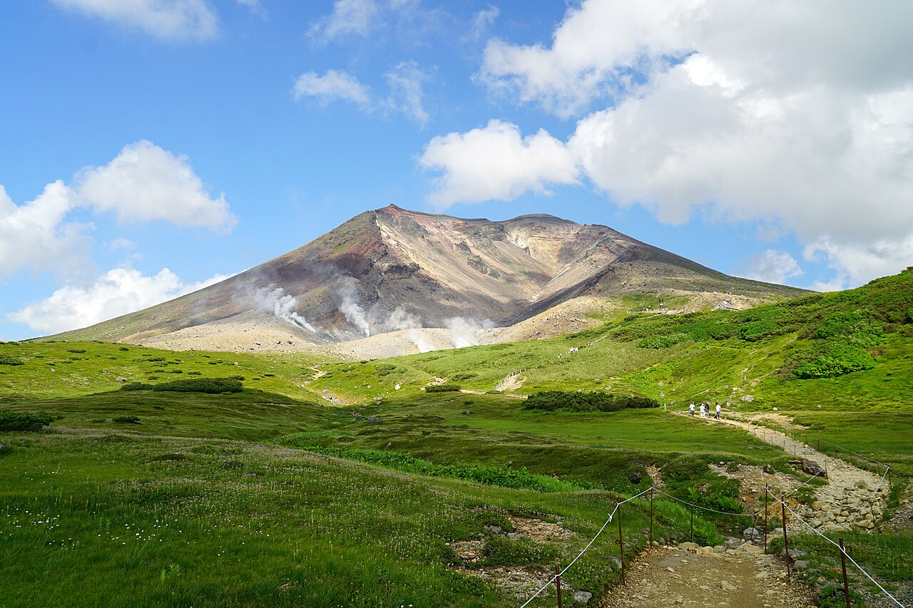
Conditions: an alpine zone at 43° north
Even in midsummer, residual snowfields persist on the upper mountain, and the average summit temperature in August is around 10 °C — about the same as on a 3,000 m peak farther south. First snowfall on the summit has been recorded in early September. Dress as for an exposed 2,500–3,000 m peak in the Northern Alps: long-sleeve baselayer, fleece or synthetic midlayer, a real rain shell on both top and bottom, gloves, beanie, and ankle-supporting hiking boots. Carry water — there is no reliable source between Sugatami Station and the summit.
The fumaroles of Jigokudani sometimes release sulphur-rich gas across the trail. The Japan Meteorological Agency keeps the volcano at alert level 1 (active) and updates the level daily; check before climbing, and bring a buff or bandana that can be dampened across the mouth on gassy days.
Asahidake is the earliest place in Japan to see autumn colour. The slopes around Sugatami begin to turn red in early September, weeks ahead of the Northern Alps and over a month before the Tokyo region. The third week of September is the peak — and one of the busiest times of year on the ropeway.
The view from the top
From the elongated summit ridge you look out across nearly the entire Daisetsuzan plateau: Mt. Kuro to the northeast, Mt. Hakuun and Mt. Tomuraushi to the southeast, and on rare clear days the Hidaka range of southern Hokkaido and the Shiretoko volcanoes of the east coast. Few places in Japan offer this much volcanic terrain in a single panorama. Asahidake Onsen below has a small cluster of inns with simple sulphur baths; the natural follow-up climb is either Mt. Kuro via the Sounkyo Ropeway or a multi-day traverse south to Tomuraushi.


